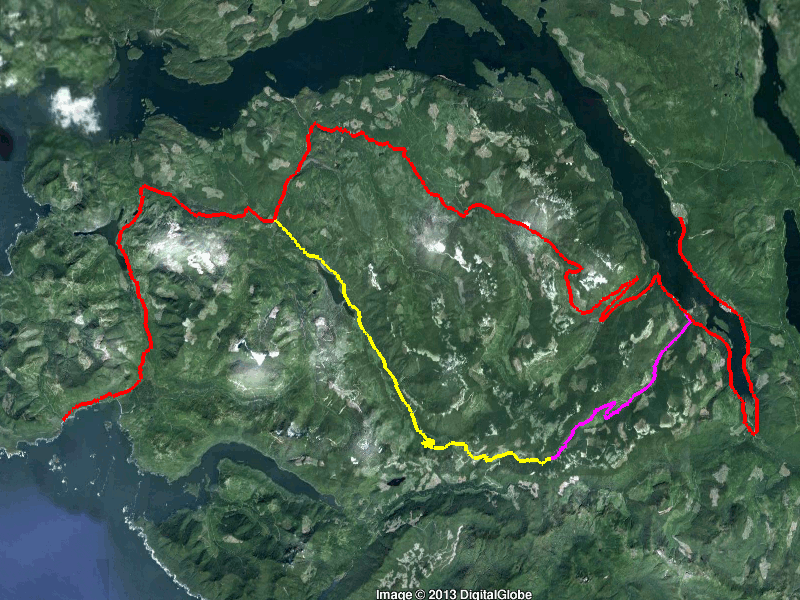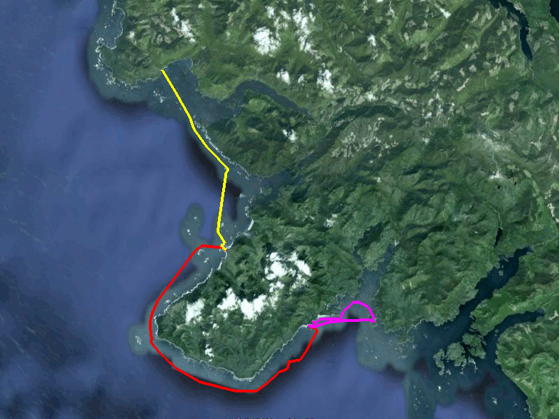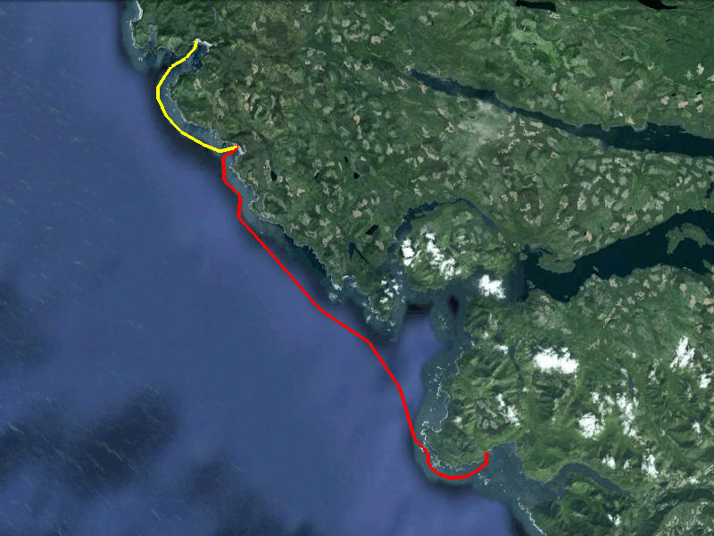
yellow/violet - my proposed route
violet - how far I got
red - the correct route
I was ready to paddle around the Brooks peninsula. I wanted to go from San Josef Bay to the south side of the Brooks peninsula. That would fill in the gap between the 2005 trip and the 2006 trip. But the logistics were a problem. The closest road access to the South Brooks is Fair Harbour. Both Fair Harbour & San Josef Bay are about 4 hour drives from Campbell River.
After weighing various options, I decided to drive to Side Bay and launch from there. I would paddle the Brooks peninsula from north to south and then I would paddle it from south to north. If I still had time, I would resupply at the truck and paddle north to San Josef Bay and then return to the truck.
I had been told that the road to Side Bay was a tire killer, so I took 2 spare tires, 2 cans of tire repair foam, and a tire plug kit.

|
|
Brooks Roads
yellow/violet - my proposed route violet - how far I got red - the correct route |
The Brooks peninsula roads aren't on normal road maps. I looked at the driving description to Side Bay in the Wild Coast I:
The most direct route is via Cayuse Main/Klaskish Main, but it's gated in two locations (Interfor gates) and isn't well marked. A longer route via Teeta Pass, K Main, I Main, J Main, then Klaskino Main is recommended. It's comparitely well marked.
What I should have done was to find each Main in the Backroad Mapbook (they are well labelled). But instead I looked at Google Earth and created a path that followed obvious roads from Pt Alice to Side Bay. I loaded that path in my gps and I was all set. So I thought.
My proposed path put me on Cayuse Main, which became very rough a short way off Marine Drive. Since I was expecting a tire-eater road, this did not ring any alarm bells. It should have! After taking almost an hour to travel 12 kilometers, I turned off Cayuse Main onto my side road, but only got 1 kilometer further before the road was semi-washed out. I walked up it a short way but it didn't look that promising.
I dug out my copy of WC1 and looked at the directions again. It was time to retreat and try Teeta Main. As I drove back out to Marine Drive, it took a real effort to drive slowly when I knew I had wasted 3 hours. But a flat tire would just cost me more time, and reduce my chances of getting to Side Bay (and out!) with 4 intact tires.
Eventually I got back to Marine Drive and proceeded to Teeta Main. The road went through an active logging site and was covered in slash, but once through that, the road was good. Really good. The side roads were reasonably well signed but the correct fork was usually obvious.
WC1 states that it wasn't obvious where the turnoff down to the ocean was. I couldn't see it at all in Google Earth. I did have a picture looking northeast from the beach and was able to use google earth to match the view; this gave me the approximate location. But when I got there, the short turnoff down to the ocean was obvious.

|
|
kayak campers at Side Bay
|
There wasn't much for parking; just a small clearing for one vehicle, and a spot on the beach. The stream looked like a good source of water. I talked to 3 kayakers who were camped on the beach and they said the grassy upper beach was buggy. So I just slept in my truck above the beach.

|
|
first leg
|
A relatively short hop through Brooks Bay puts you at the Crabapple Islets. They are both joined by sand spits to the main beach. The easterly sand spit was submerged at high tide; while the westerly one stayed dry. The spits dramatically reduce surf size if it is windy.

|
|
camp site at the Crabapple Islets This was the only campsite where I didn't see anybody. |

|
|
sunset at the Crabapple Islets
|

|
|
walking the beach west of camp 9 am
|
The forecast called for NW winds 15-25 knots with 20-25 south of the Brooks. I was back in camp after a beach hike when I caught the Solander wind report of 11 knots. It had been 7 knots an hour earlier; while Quatsino & Nootka lighthouses had been NW 3 and NE 5 an hour earlier. Since the forecasts for the next 3 days were for higher NW winds, I decided on the spur of the moment to try and get to Nordstrom Creek. Another factor in my decision making was that the Friday forecast called for south winds in the afternoon, which would make the return trip easier.

|
|
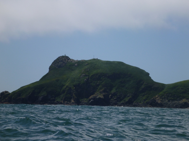
Cape Cook & Solander Island
|

|
|
Solander Island
|
I didn't leave camp till 11:30, but Solander was still reporting 11 knots as I approached it. It was basically calm at Cape Cook; with just some wave action as the swell moved into the shallows. At the south end of Solander Island I was past the biggest of the waves; and raised the sail. You might think that having a sail in front of me would make it harder to dodge the rocks and reefs between Cape Cook and Solander Island; but I had taken the precaution of programming a track into my gps that avoided the rocks. While under sail, it was relatively easy to steer and follow the track. The sailing did get exciting at times, as gusts tried to push the sail over. I found my new carbon fiber greenland paddle to be extremely trustworthy as an outrigger as I could fully extend it and put lots of force on it. I used a combination of stern rudders and skimming braces to steer the kayak and keep it upright.
I sailed south to Clerke Point, where I lowered the sail. The wind direction was too far off my desired direction; and I was unwilling to chance the sideways push from gusts. Once around Clerke Point I again raised the sail; which pushed me out from shore. This became a problem as I hit the outflow from Cladothamnus Creek, which surely translates to "blow you out to sea" creek. Lowering the sail, I paddled to little avail for an hour, and then ran with the wind at an angle until I escaped the main force. From there it was a calm paddle to a sandy beach.

|
|
a sweeping sand beach on the south side of the Brooks Peninsula
|

|
|
bear tracks on the beach
|
There was a group of hikers camped on the beach; and they warned me that the resident bruin was not shy. I encountered him while I was moving my gear away from his regular route; but after glaring at me, he continued on his way. The campers also told me that the small enclosed beach that Kimantas recommends as a storm-proof beach seemed to be the bruin's hangout.

|
|
protecting the boat
|
I took a day trip south the next day, to overlap my trip of 2006. This was a short casual where I just poked into nooks & crannies. The next two days were stay-in-camp days, as the forecast called for respective winds of S 20-30 knots and NW 15-25. I had a long-overdue rolling session one day; I had neglected my rolling in favour of distance paddling in preparation for this trip.

|
|
wolf tracks on the beach
|

|
|
second leg
|
On Friday however, the forecast was for NW 15 changing to SW 10. I was up early and left camp at 0630. Conditions were calm until I met a small headwind at Clerke Point. This persisted until north of Nordstrom Creek, where the wind died out. I had been monitoring conditions at Solander Island, and the wind there had dropped from N 13 to N 9 to N 7.

|
|
the back side of Solander Island
|
On this leg, I avoided the rocks and reefs by crossing over to Solander Island and paddling around the backside. I found some very lively clapotis as the incoming swell bounced off the island. At Cape Cook, it felt like I was paddling against current, so I veered a bit north to make progress. After that, I was able to stay close to shore and made my way back to the Crabapple Islets.

|
|
a well deserved beer
|
The next morning, I watched the clouds streaming over the Brooks Peninsula; yet the ones draped over the mountains near Klaskish Inlet were still. I paddled and sailed back to Side Bay, trying to utilize the moderate wind coming out of Klaskish Inlet. At Side Bay I re-supplied provisions and fuel. I made a serious mistake here as I slept in the back of my truck. I should have packed up and gone to Lawn Point; as a group of rednecks from Mission BC ran quads up & down the beach at 3 am.
Despite the lack of sleep, I launched at 0640. I followed two sea lions as we worked our way through the reefs off Lawn Point. There was enough swell to mark the boomers but the wind stayed fairly calm as I crossed Quatsino Sound.

|
|
Quatsino Lighthouse
|

|
|
The main beach at Grant Bay was busy, so I camped at a small beach to the west |

|
|
looking south from Grant Bay
|
I took two days to paddle to San Josef Bay, stopping overnite at Topknot Bay. It was a nice change to camp on pea gravel. The landing was reasonably protected, and a small creek was nearby. I saw a bruin feeding alongside the main creek, but he never came near my camp.

|
|
the view from Topknot Bay
|
After leaving the beach the next day, I found that my skeg was stuck. Since I could not reach the cord, I paddled back and into the creek to land and fix it. The creek is totally protected from swell. It has a nice sandy beach but the elevation is too low to camp on.
Since the morning swell was small, I detoured into Raft Cove to check out the landing options. I found a good one, but it involved threading a narrow lane between an exposed reef and a boomer.
I continued on to San Josef Bay through a couple of small squalls. This was a very gray day; which generally makes for windless travel but lousy pictures.

|
|
paddling into San Josef Bay on a gray day
|

|
|
San Josef Bay
|
According to the forecast, I should have turned around and headed south. However, I wanted a rest day, so I stayed put. It was sunny, so I did some beach walking. There were a number of campers in the area, but I was off the main beach and did not feel crowded.

|
|
waterfall at San Josef Bay
|

|
|
looking towards the San Josef river
|
There are two little islets semi-connected to the beach. At low tide, one can walk along the base of the headland (pictured) where they join. I went exploring at a higher tide, so I took the muddy overland route. On the way back, I opted for the over-the-knees wade instead. The above picture is taken from one of the islets, with the second one in the background.

|
|
third leg
|
The next day I paddled a short distance south to Raft Cove in fog, wind, and a larger swell. I justified the less than optimal travelling conditions with the problem that San Josef was too far north for staging purposes. The larger swell made me glad that I had checked out the landing approach two days before.

|
|
surf at Raft Cove
|

|
|
the Raft Cove sauna
|
There were various shelters in the woods just above the beach. One of them had this well constructed sauna. No benches, but it did have a metal bucket.
This day was a travelling day. The forecast was for NW 15 winds, with mainly S winds over the next 4 days. The surf in Raft Cove was sizeable, but I got out without having a wave break on me. A grey whale surfaced near me south of Topknot Point, and I saw him a couple more times in the area. After a couple of hours of paddling I was able to raise the sail.

|
|
sailing south in Quatsino Sound
|
The wind stayed below 10 knots, but it was still refreshing to have a tailwind instead of a headwind. The wind enabled me to readjust my destination from Grant Bay to Rowley Reefs, and eventually to Side Bay.
I lowered sail to work through the boomers near Lawn Point but raised it again for the short hop between Lawn Point and Rugged Island. After 8 hours in the yak, I landed at Side Bay.
As I was driving out, I met a company truck, who announced my presence on the radio. I heard him announce several other vehicles before I got to Port Alice.
After two hours on the logging roads, I arrived in Port Alice. After a twisty paved road and a bite to eat in Port McNeil, I was ready for the run south to Campbell River.

|
|
sunset from Crabapple Islets
|