I've been paddling the coastline of Vancouver Island in sections, bit by bit. Some years I get to do a three week trip, other years it's just one week. This year it was time to have a look at Johnstone Strait. I also wanted to get a glimpse of the Broughton Archipelago, so I worked in a detour. The detour gave me the bonus of checking out the tidal rapids in Chatham Channel.

|
|
GPS tracks for each day
|

|
|
Port Hardy launch point (red)
|
You might be tempted to use the yellow line as a launch/landing path because it is next to the information booth. It dries at low tide to become a wide rough beach. This time I found a better launch point further north (red line).

|
|
Deer Island East of Port Hardy
|
There are a couple of large campsites on Deer Island; if I was to go back I'd phone to get permission to camp there. I continued to a tiny beach on Eagle Island.
It was calm the next morning, so I paddled straight to Malcolm Pt. Currents had been favorable till then, but a countercurrent along the north side of Malcolm Island slowed me down.

|
|
looking across Queen Charlotte Strait towards Numas Islands (from Malcolm Pt)
|
The rumoured camping beaches west of Lizard Pt were covered in wood. I landed several times looking for something suitable. I had to get up off the beach because the high tide at Alert Bay was 17 feet at midnight. Eventually I found an abandoned shack in the woods with a not so flat area nearby.
This was an ugly carry next morning at a low tide of 2 feet, taking a full hour just to move gear & boat. The favorable flood was partially countered by a SE wind, but it was still an enjoyable paddle through Blackfish Sound. The last stretch to Flower Island was against a stiff headwind. I stopped for lunch at the very nice gravel beach on Flower Island.

|
|
gravel beach on Flower Island
(the sail is up so I can get my lunch) |
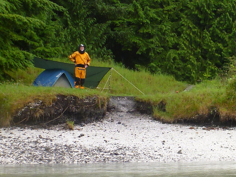
From Flower Island I weaved through small channels to get to Mound Island. There I talked to Vic T of Victoria, a SISKA paddler and an aquaintance of Mike Jackson. He invited me in out of the rain, but I pressed on so I would be in position for Chatham Channel the next day. Vic was the only kayaker I saw all trip.

|
|
Vic T from Victoria on Mound Island
|
I continued against the wind, past Dead Point Village, and into Beware Passage. It was windy here as well, and there was a strong current against me near Care Island. When I got to Baronet Passage, there was a strong wind opposing the current. I was pushed west and then worked my way back east by paddling very close to the shoreline of island 49. I was then able to turn the corner to Klaoitsis Island.

|
|
The nice clamshell beach on Klaoitsis Island
|
My neck gasket split while taking my drysuit off. I trimmed off two rings and patched it with duct tape and aquaseal. This suit has a ring of fabric outside of the gasket that can be tightened with velcro. That should help to slow down any water intrusion.
I was unable to find a level spot at the top of the beach, so I spent an hour trimming rosebushes that had overgrown the path to the tent site. It was nice to have leather gloves and a small folding saw.
The carry next morning was better than Lizard Pt, but it was still a nuisance. I wanted to pass the tidal rapids in Chatham Channel between 11 am and noon (2 & 4 knots respectively). This was 21 km away so I had to be on the water between 7:30 and 8:30. For optimum travelling wrt current, I wanted to be at Lagoon Cove at the 10 am slack current. If I was there before the 10 am, then I would have ebb against me in Chatham Channel. If I was there after 10 am, then I would have flood against me in Clio Channel.

|
|
Current Plots
|
I had a slight tailwind in Clio Channel so I put up the sail. The breeze died out at Lagoon Cove and was replaced by a contrary current. After a short paddle through the Blowhole, I was heading south in Chatham Channel. I picked up a slight tailwind in Chatham, and went through the rapids with about two knots assisting me. I paddled against a headwind for all of Havannah Channel and hugged the shore for most of it.
I stopped at Broken Island to look at tent sites. They were pitiful. The low tide would have meant a long carry. I had some lunch and carried on. There was a good tailwind in Johnstone Strait and I put up the sail. I had been hoping for lots of good sailing in Johnstone Strait, but this was the only time I did not have to paddle as well.

|
|
Johnstone Strait just east of the Adams River
|
I landed at St Vincent Bight. Access to the forest was difficult and tent sites were so-so. I moved some logs and set up my tent at the very top of the beach. Well $#!!, that wasn't high enough and I had to get up at 1 am to empty my tent and put it on top of some logs. While I was doing this, a passing tug on the other side of the channel saw my headlamp and shone a floodlight at me to see if I needed assistance. I quickly shielded my light. My tent site was covered by an inch of water by 2 am, and I was back in the tent at 3:30.
The ebb meant I was paddling near shore for most of the morning. Just before Sayward, I veered towards Helmcken Island. I had intended to let the flood push me along the south shore, but a strong current at the western tip drew me north. Once past the rip, I encountered a contrary ebb current from Chancellor Channel. I stopped for lunch in Billygoat Bay, then made my way to the east point of Helmcken, where I transitioned into the swift flood flowing east along the south side. Just west of Ripple Shoal, the flood tried to pull me into Chancellor Channel, but I fought towards Camp Pt until I could miss the turbulence at Ripple Shoal. The whole area near Helmcken Island has complicated currents.
I was unable to land directly at the campsite south of Vansittart Pt; I had to let the strong flood push me past it, and then go back via the strong countercurrent along shore. The flood here is much stronger than what you would expect from the prediction at Johnstone Strait Central west of Yorke Island.
The welcome sunshine allowed me to dry all my wet gear while I collected some water. I use a gravity filter which is an excellent bit of gear. I have it set up so it flows directly into a dromedary.
An easy launch down the gravel beach next morning meant an early start. I wanted to get to Chatham Pt for the low slack at 12:30. The ebb was against me the whole way, but I used the shore countercurrent as much as possible.

|
|
looking east near Bear Point in Johnstone Strait
|
I paddled against the ebb for 5 hours and reached Chatham Pt at slack. I knew I could not reach Seymour Narrows in an hour and a half to run it at a safe current level, so I had a leisurely paddle to Browns Bay. I got to kill some time there while I waited for the current to drop.

|
|
Currents at Seymour Narrows
|
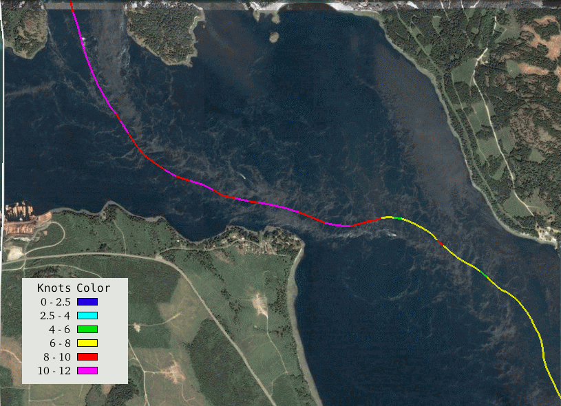
There were two factors influencing the time I went through the narrows: (1) if I went too early, the current would be too high (2) if I went too late, the turn to ebb would catch me before I got to Campbell River. I decided I wanted to be under the hydro wires at 6 pm. This would give me a max current of 10 knots but it would drop quickly. It would give me a good chance to get to CR before the flood died. My timing was good and I had a fast ride through the Narrows to Race Pt. The next picture is my gps track superimposed on a satellite view of the flood. As you can see, I chose a line that went through very little turbulence.

|
|
My GPS track at Seymour Narrows and Race Pt
|
As the next image shows, I made it almost all the way to the Campbell River estuary before the flood started to weaken. So I was pretty happy with my timing, which I was able to plan and execute because I had been through Seymour Narrows 35 times prior to this trip.

|
|
My GPS Track from Seymour Narrows to Campbell River
|
While this trip is devoid of west coast swell, it is affected by ebb & flood currents. I made tide or current plots at 24 different locations, and I did this for each of 4 days. These plots were collected into 6 8.5x11 inch printouts which were laminated back to back to make 3 pages.

|
|
One of the 6 pages of Current/Tide graphs I had laminated to take with me
|
SUMMARY:
I prefer trips on the west side of Vancouver Island because of the wildlife, ocean swell, and beaches. This trip was semi-interesting because of the currents and because it was new territory for me. I would repeat it only if the sailing was good.
NOTES: